Mission Drishti
Mission Drishti
India’s Leap into Multi-Sensor Earth Observation
India’s space sector stands at a transformative moment with the announcement of Mission Drishti, the world’s first multi-sensor Earth Observation (EO) satellite developed by GalaxEye Space, a private space-tech startup based in Bengaluru. Scheduled for launch in early 2026, Mission Drishti represents a major advancement in global space innovation by combining multiple sensing technologies into a single satellite platform. This pioneering initiative not only reinforces India’s presence in the evolving private space ecosystem but also signifies the nation’s ambition to achieve leadership in Earth Observation and geospatial intelligence.
The Vision Behind Mission Drishti
Mission Drishti derives its name from the Sanskrit word Drishti, meaning “vision.” The satellite embodies India’s vision of achieving sharp, integrated, and intelligent observation of the planet. Developed by GalaxEye Space, an IIT Madras alumni-founded enterprise, the mission highlights the growing synergy between academic innovation, private entrepreneurship, and national technological ambition.
At its core, Mission Drishti seeks to address a critical gap in Earth Observation technology — the fragmentation of data sources. Traditionally, satellites are equipped with either optical sensors or Synthetic Aperture Radar (SAR) systems, but not both. Optical satellites are ideal for daylight and clear-weather imaging, while radar-based satellites provide visibility even through clouds or darkness. Mission Drishti’s design uniquely integrates both sensor systems into one spacecraft, offering 24×7, all-weather global observation capability.
This combination ensures continuous monitoring without dependence on external datasets or conditions. Furthermore, the satellite’s ability to simultaneously process radar and visual data will redefine precision mapping, resource management, and strategic intelligence, pushing India’s EO capabilities far ahead of existing global benchmarks.
Technical Features and Innovations
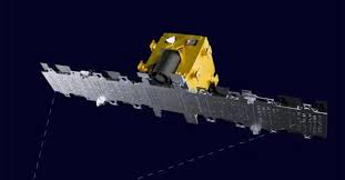
Mission Drishti stands out as a symbol of engineering excellence and data integration innovation. At 160 kilograms, it will be India’s largest privately built satellite, combining hardware sophistication with software-driven analytics. The spacecraft incorporates two major technological systems — Synthetic Aperture Radar (SAR) and optical imaging sensors, engineered to operate in tandem.
The SAR component will deliver high-resolution radar imaging capable of penetrating cloud cover, assessing terrain structures, and monitoring ground movement even in adverse climatic conditions. The optical sensor component, meanwhile, captures detailed visual imagery under daylight, enabling accurate surface interpretation and environmental analysis. This dual-sensor synergy provides a 1.5-meter resolution, ranking among the finest in global EO satellites.
Adding further depth, Mission Drishti employs AI-driven data analytics to fuse multi-source information and deliver actionable insights. The combination of radar and optical data through artificial intelligence produces an integrated image that holds greater accuracy and utility than any single-sensor satellite. These capabilities will directly support precision-driven planning and management across civilian and defense domains.
Applications Across Sectors
The launch of Mission Drishti is expected to revolutionize how industries and governments utilize geospatial data. Its real-time, all-weather imagery can be applied in diverse areas:
- Disaster Management: Early detection and assessment of floods, cyclones, and landslides through radar-visual fusion, enabling timely rescue and planning.
- Defense and Border Surveillance: Continuous visibility across terrains and weather conditions, assisting in strategic monitoring and national security operations.
- Agriculture: Crop health assessment, irrigation planning, and soil analysis using combined spectral and radar indices.
- Infrastructure and Urban Planning: Mapping of roads, city growth, and construction progress with enhanced precision.
- Climate and Environmental Studies: Monitoring glacier melts, forest density, and oceanic changes to support climate modeling.
- Financial and Risk Analysis: Insurance and financial institutions can use verified land-use data and natural hazard predictions for asset protection.
Through these integrated applications, Mission Drishti will serve as an essential tool for data-driven governance, where decisions rely on validated, multi-sensor information. Governments, corporations, and research agencies can utilize satellite imagery for transparent monitoring, resource allocation, and sustainable development planning.
India’s Strategic Advantage in Earth Observation
Mission Drishti carries profound strategic implications for India and the global space economy. By developing this satellite indigenously, India enters a league of technological leadership that traditionally belonged to established space powers. The initiative signifies a shift from data dependency to data sovereignty — enabling India to produce, process, and control its own high-resolution EO data rather than relying on foreign sources.
The mission also complements the national vision of Atmanirbhar Bharat and aligns with Viksit Bharat 2047, focusing on innovation-driven self-reliance and global competitiveness. The private space industry’s increasing participation, aided by supportive government policies and the Indian Space Research Organisation (ISRO)’s collaboration model, reflects a maturing national ecosystem capable of independent space capabilities.
Moreover, GalaxEye’s announced plan for a constellation of eight to ten Drishti satellites over the next four years will amplify India’s Earth Observation network into a global data grid. This cluster will enable continuous monitoring of the planet, ensuring redundancy, temporal coverage, and geo-specific insights across sectors such as logistics, defense, and climate science.
The Rise of Private Space-Tech Innovation in India
The development of Mission Drishti exemplifies how India’s private space-tech sector has evolved beyond small-scale payloads to sophisticated, end-to-end missions. GalaxEye Space, founded by young technologists from IIT Madras, symbolizes new-generation innovation where startups lead with original ideas rather than incremental adaptation.
The company’s approach emphasizes collaboration with both government and academic institutions, integrating research excellence from premier universities and operational experience from space agencies. Such partnerships create an ecosystem where indigenous technology thrives, generating global standards rather than merely following them.
Notably, GalaxEye’s entry into Earth Observation transforms India from a data consumer to a potential data exporter. With growing global demand for accurate geospatial information — especially in climate and security domains — Indian private players can emerge as providers of premium EO services. Mission Drishti thus represents both a technological milestone and a commercial gateway for India in the worldwide space economy.
Sustainability and Future Outlook
Beyond its technical prowess, Mission Drishti emphasizes sustainable development through eco-conscious design and intelligent data use. The satellite’s observations can help model energy-efficient infrastructure, promote green agriculture, and manage natural resources with minimal environmental impact. In this sense, it directly supports the United Nations Sustainable Development Goals (SDGs), especially those concerning climate action, sustainable cities, and industry innovation.
As global challenges such as extreme weather events, food insecurity, and resource depletion intensify, Mission Drishti’s capabilities offer practical solutions for evidence-based policy actions. The mission not only promises improved data but cultivates the habit of scientific decision-making among institutions and communities. Through transparent data sharing, it can facilitate international cooperation and bridge the gap between technology and humanitarian needs.
Looking ahead, GalaxEye plans to expand partnerships with ISRO, defense agencies, and global research organizations to develop an integrated observation network spanning continents. Such a vision reflects how private innovation blends with national policy to create outcomes that serve both domestic priorities and global needs.
Conclusion: A Turning Point in Earth Observation
Mission Drishti epitomizes India’s aspiration to merge innovation, sustainability, and security into a single spatial vision. By combining Synthetic Aperture Radar and optical sensors on a unified platform, the mission introduces a category of Earth Observation that goes beyond traditional limits of weather and visibility. It signifies India’s rise as a technological trailblazer, ready to lead in climate intelligence, defense monitoring, and sustainable resource management.
As the mission approaches its launch in 2026, it stands not merely as an engineering feat but as a statement of purpose — that India’s space ambitions now converge with global scientific progress. By fusing data, vision, and technology, Mission Drishti turns the Earth into a clearer, smarter, and more connected world, fulfilling the promise of India’s evolving role in twenty-first-century space exploration.