
Light Detection and Ranging (LiDAR)
04.11.2024
Light Detection and Ranging (LiDAR)
|
For Prelims: About LiDAR, Working of LiDAR, Applications of LiDAR |
Why in the news?
Recently, scientists have detected a lost Mayan city, hidden for centuries in the dense Mexican jungle, using LiDAR.
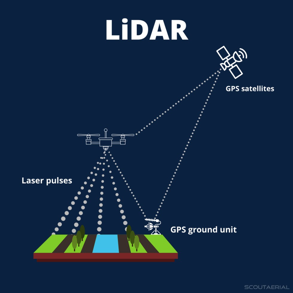
About LiDAR:
- Light Detection and Ranging (LiDAR) is a remote sensing technology that uses light in the form of a pulsed laser to measure ranges (or variable distances) of a sensor, usually mounted aboard an aircraft, to Earth’s surface.
- LiDAR data can be used to create high-resolution 3-D models of ground elevation with a vertical accuracy of up to 10 cm.
Working of LiDAR:
- LiDAR instrumentation comprises a laser, a scanner, and a GPS receiver.
- The rapidly firing laser travels to the ground where it hits vegetation, buildings, and various topographic features. This light is reflected or scattered, and recorded by the LiDAR sensor.
- The system calculates the light pulses’ two-way travel time to arrive at the distance between the terrain and the sensor.
- It processes this information with Global Positioning System (GPS) and Inertial Measurement System (IMS) data, to create an elevation map of Earth.
- LiDAR data is initially collected as a “point cloud” of all individual points reflected from everything on the surface, including structures and vegetation.
- The specific of how much light energy was returned to the sensor allows further identification of different features, such as vegetation, buildings, etc. For example, tree canopies, however dense they may be, allow some light to pass through and hit the ground.
- Its data can be further refined to produce what scientists call a “bare earth” Digital Elevation Model, in which structures and vegetation are stripped away.
Applications of LiDAR:
- It is used to generate precise, three-dimensional information about the shape of the Earth and its surface characteristics.
- This is obviously very useful information for geographers, policymakers, conservationists, and engineers.
- It has also shown potential as a tool of archaeological discovery.
Source: Indian Express
Consider the following statements regarding Light Detection and Ranging (LiDAR):
Statement-I:It is a remote sensing technology that uses light in the form of a pulsed laser.
Statement-II:It is used to generate two-dimensional information about the shape of the Earth and its surface characteristics.
Which one of the following is correct in respect of the above statements?
A.Both Statement-I and Statement-II are correct, and Statement-II is the correct explanation for Statement-I.
B.Both Statement-I and Statement-II are correct, and Statement-II is not the correct explanation for Statement-I.
C.Statement-I is correct, but Statement-II is incorrect.
D.Statement-I is incorrect, but Statement-II is correct.
Answer C