
Pontus Tectonic Plate
13.10.2023
Pontus Tectonic Plate , Daily Current Affairs , RACE IAS : Best IAS Coaching in Lucknow
|
For Prelims: Pontus Tectonic Plate For Mains GS paper 3: Tectonic Plate,The significance of Plate Tectonics Lithosphere |
Why in the news?
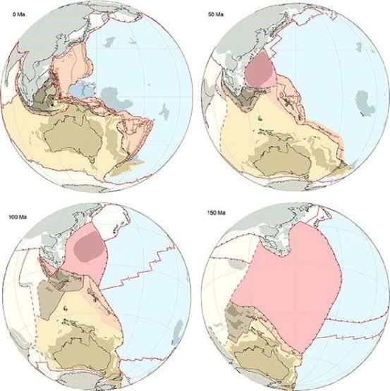
A long-lost tectonic plate dubbed 'Pontus' was recently discovered by chance by scientists studying ancient rocks in Borneo.
About Pontus Tectonic Plate:
- It is a long-lost tectonic plate recently discovered in the west Pacific Ocean.
- It is believed that the massive tectonic plate was once about 15 million square miles in size, which equates to approximately one quarter of the Pacific Ocean.
- It can be traced back as far as 160 million years, and even more recently to around 20 million years back.
- Plate thickness varies greatly as well, ranging from less than 15 km for young oceanic lithosphere to 200 km or more for ancient continental lithosphere (for example, the interior parts of North and South America).
- It was slowly subducted and lost over millions of years, pulled down under a neighbouring plate by gravity.
How was the discovery made?
- The discovery of the Pontus plate enhances our understanding of tectonic activity and subduction processes. It also has significant implications for predicting and mitigating natural hazards such as earthquakes and tsunamis.
- The subducting plate is actually denser than the surrounding mantle, so gravity basically pulls the plate down into the mantle.
- A subducted plate leaves behind traces when it 'sinks' into Earth's mantle – namely, fragments of rock hidden in mountain belts.
- During the process of subduction, however, the upper parts of the subducting plate are sometimes scraped off.
- The researchers used geological data to reconstruct the movements of the current plates with computer modelling, which hinted at a wide area potentially vacated by a subducted plate.
- Using magnetic techniques, researchers determined the basalt from Borneo were relics of Pontus that were left behind when this part of the plate subducted, some 85 million years ago.
Tectonic Plate
Historical Background
The idea of continental drift, the precursor to plate tectonics, was first proposed by the German meteorologist Alfred Wegener in the early 20th century. Wegener proposed that continents were once part of a single supercontinent called Pangaea and have since drifted apart to their current positions.
What is a Tectonic Plate?
- The term tectonics comes from the Greek word “tektonikos” meaning “to build.” Geologically “plate” means a large slab of rock. Together the terms indicate how Earth’s surface is made of large slabs of rock.
- It is a massive, irregularly shaped slab of solid rock, generally composed of both continental and oceanic lithosphere.
- Plate size can vary greatly, from a few hundred to thousands of kilometers across; the Pacific and Antarctic Plates are among the largest.
- It was from the continental drift theory, convection current theory and the theory of seafloor spreading, the theory of Plate Tectonics was formulated.
Force for plate movement
Convection currents in the mantle that are generated due to thermal gradients.
Rates of Plate Movement
- The Arctic Ridge has the slowest rate (less than 2.5 cm/year), and the East Pacific Rise in the South Pacific (about 3,400 km west of Chile), has the fastest rate (more than 15 cm/year).
Major tectonic plates
- Antarctica and the surrounding oceanic plate
- North American plate
- South American plate
- Pacific plate
- India-Australia-New Zealand plate
- Africa with the eastern Atlantic floor plate
- Eurasia and the adjacent oceanic plate
Minor tectonic plates
- Cocos plate: Between Central America and Pacific plate
- Nazca plate: Between South America and Pacific plate
- Arabian plate: Mostly the Saudi Arabian landmass
- Philippine plate: Between the Asiatic and Pacific plate
- Caroline plate: Between the Philippine and Indian plate (North of New Guinea)
- Fuji plate: North-east of Australia
- Turkish plate
- Aegean plate (Mediterranean region)
- Caribbean plate
- Juan de Fuca plate (between Pacific and North American plates)
- Iranian plate.
The significance of Plate Tectonics
- Almost all major landforms formed are due to plate tectonics.
- New minerals are thrown up from the core with the magmatic eruptions.
- Economically valuable minerals like copper and uranium are found near the plate boundaries.
- From present knowledge of crustal plate movement, the shape of landmasses in future can be predicted.
- For instance, if the present trends continue, North and South America will separate. A piece of land will separate from the east coast of Africa. Australia will move closer to Asia.
Types of Plate Boundaries
There are three types of plate boundaries:
- Divergent Plate Boundaries
- These plates move away from each other consistently are called Divergent Plate Boundaries.
- This type of interaction results in the formation of mid-ocean ridges (such as the Mid-Atlantic Ridge).
- Convergent Plate Boundaries
- When continental and oceanic plates collide, the oceanic plate, which is thinner and denser, is pushed aside by the continental plate, which is thicker and less dense.
- In a process known as "subduction," the oceanic plate is driven down into the mantle.
- The oceanic plate is thrust into higher temperature environments as it lowers.
- Materials in the subducting plate begin to approach their melting temperatures at a depth of about 100 miles (160 kilometres), and partial melting begins.
- Transform Plate Boundaries
- Two plates slide past each other in this type of interaction, and no new landforms are created or destroyed; only the present landform is deformed.
- Transform faults are planes of separation in the oceans that are often perpendicular to the mid-oceanic ridges.
What is the Lithosphere?
- The term lithosphere is derived from the Greek language, composed of the words “lithos” meaning rocky, and the word “sphaira” meaning sphere.
- It is the outermost shell of a terrestrial-type planet or natural satellite.
- It is composed of the crust and the portion of the upper mantle, which compose the rigid and hard outer layer of the Earth.
- The lithosphere reacts to the atmosphere, hydrosphere, and biosphere to initiate the soil-forming process called the pedosphere.
- It can extend to a depth of more than 100 km (or 60 miles) but generally has a thickness between 35 to 50 km in the continental regions.
Types of Lithosphere
- Oceanic Lithosphere
- The lithosphere associated with oceanic crust and exists in the ocean basins is called the oceanic lithosphere.
- It is the portion of the upper mantle and crust present underneath the ocean and seas.
- The oceanic lithosphere tends to be denser than its counterpart the continental lithosphere.
- Continental Lithosphere
- It is linked with continental crust.
- It has an average thickness range from about 35 to 45 km. It comes into direct contact with the atmosphere.
- It is composed of a layer of igneous and sedimentary rock that forms the continents.
- This layer consists mostly of granitic rock.
Source: Times of India