Working of Global Positioning System (GPS)
Working of Global Positioning System (GPS)
Important for Prelims:
Global Positioning System, Standard Positioning Service (SPS), GNSS (Global Navigation Satellite System), Atomic Clocks, Indian Regional Navigation Satellite System (NavIC), GPS-Aided Geo Augmented Navigation (GAGAN)
Important for Mains:
GS-3: India's achievements in Global Positioning System, Science & Technology, Space Technology
09 December,2023
Context:
In the present modern era of technology, like the technical devices used in daily activities, Global Positioning System (GPS) has also had a revolutionary impact.
- The widespread use of this technology has significantly changed our expectations, from civilians to military, from precise scientific studies to urban planning and disaster risk assessment.
About Global Positioning System(GPS):
- The GPS program was started by the US Department of Defense in 1973 and launched the first satellite in 1978.
- The modern GPS satellite constellation consists of 24 satellites revolving around the Earth in six orbits. Each satellite completes two orbits in a single day.
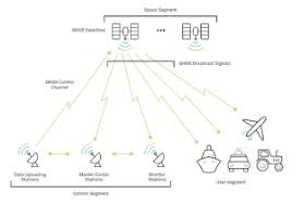
Main components of GPS:
- A GPS program has three main components – the space segment, the control segment, and the user segment.
Space segment:
- The space segment consists of 24 satellites. The six orbits they go into are all 20,200 km above Earth, and each orbit has four satellites at all times.
- In this configuration, any person on Earth will be able to 'see' at least four satellites at a time, which is a critical requirement.
Control segment:
- The control segment consists of a global network of ground-based control stations and antennae that track the 24 satellites, ensure their performance is as expected at all times, and transmit commands.
- The services provided by GPS systems are designed to meet the Standard Positioning Service (SPS) performance standard, the latest version of which was published in April 2020.
- The SPS standard brings the benefits of GPS systems to application developers and users around the world.
GPS Master Control Station:
- The GPS master control station is located at Schriever Air Force Base, Colorado, and an alternate master control station is located at Vandenberg Air Force Base, California.
- Ground antennas are in Florida (Cape Canaveral), Ascension Island, Diego Garcia Island and Kwajalein Atoll.
- Monitoring and tracking stations are in the U.S. states of Hawaii, Alaska, New Hampshire, Washington D.C., Colorado, Florida and Greenland, Ecuador, Uruguay, U.K., South Africa, Bahrain, South Korea, Guam, Australia, and New Zealand.
User segment:
- User segment deals with the use of GPS in various fields and applications.
- Major areas include agriculture, construction, surveying, logistics, telecommunications, power transmission, search and rescue, air travel, meteorology, seismology and military operations.
- The estimated number of Global Navigation Satellite System (GNNS) devices worldwide in the year 2021 was 6.5 billion, which is expected to increase to 10 billion by the year 2031, these figures underline its widespread impact.
Working of GPS:
- The GPS receiver receives and measures radio signals provided by satellites at certain frequencies (L1 and L2 frequencies at 50 bits/second), which helps in determining accurate location in three dimensions of space and one dimension of time.
- Each GPS satellite continuously broadcasts a radio signal containing information about its location in orbit, operational status, and the time the signal was emitted.
- GPS satellite signals are transmitted on the L1 (1,575.42 MHz) and L2 (1,227.6 MHz) frequencies at a bandwidth of 50 bits per second.
- The signal is encoded with Code-division multiple access(CDMA).
- CDMA allows multiple signals to be transmitted over a single channel and separated for a receiver to separate them.
- CDMA encodes signals in two modes: Acquisition mode, which can be used by civilians to access GPS data, and Precision mode, which encrypts GPS data and is for military use.
- An electromagnetic (radio) signal from GPS travels at the speed of light. The smartphone's GPS receiver picks up these signals and estimates the exact distance to the satellite.
- This distance is equal to the multiplication of the speed of light and the time taken for the signal to reach the Earth. The travel time of the signal is equal to the time at which the signal was emitted minus the time on the receiver's clock.
- If the receiver has access to signals from four satellites, it will have the information necessary to calculate its location in the four dimensions of space (three plus time) relative to the satellite clock and it accurately represents that location on Earth in 3D.
- Due to the weak gravity of the Earth, there is a difference in the time between the signal emitted from the GPS satellite and the signal received by the GPS of the smartphone and due to this time difference, the distance of the object cannot be estimated accurately.
- This can be explained by Einstein's general theory of relativity.
Accuracy and Correction:
- Atomic clocks are currently used to increase the accuracy of GPS calculations in order to maintain accurate timekeeping to ensure that the GPS system works as well as possible. For example, an adjustment to an 18-microsecond offset between clocks on satellites and the ground can result in an error of 10 km within a single day. An offset of one millisecond can lead to an error of a full 300 km. For this reason, all satellites are equipped with atomic clocks.
- In 1974, the US Naval Research Laboratory launched an atomic clock into space for the first time on the NAVSTAR NTS-I satellite.
- All clocks on the modern-day GPS constellation are synchronized within just 10 nanoseconds relative to clocks on Earth of each other.
Global Navigation Satellite Systems (GNSS) of other countries
- Many countries operate their own Global Navigation Satellite Systems (GNSS) along with GPS.
- Navigation systems are currently operated by Australia, China, the European Union, India, Japan, South Korea, Russia and the UK.
- Among these, Russia's GLONASS, European Union's Galileo and China's BeiDou systems are global.
Navigation systems of India:
Navigation with Indian Constellation (NavIC)
- India launched its own Indian Regional Navigation Satellite System in the year 2006, which was later named ‘Navigation with Indian Constellation (NavIC)’.
- It has seven satellites in space: three in geostationary orbits and four in geosynchronous orbits.
- A minimum number of satellites (four) can facilitate land-based navigation by May 2023. The main control facilities are located at Hassan in Karnataka and Bhopal in Madhya Pradesh.
- NavIC satellites use rubidium atomic clocks and transmit data in the L5 and S bands, with newer satellites also transmitting data in the L1 band.
GPS-Aided Geo Augmented Navigation (GAGAN)
- India also operates the GPS-Aided Geo Augmented Navigation (GAGAN) system, which was developed and deployed by the Indian Space Research Organization (ISRO) and the Airports Authority of India.
- The primary objective of GAGAN is to provide “security of civil aviation applications in Indian airspace” and “correction and integrity messages for GPS”.
Source: The Hindu
Mains Question
What is Global Positioning System? Discuss the usefulness of India's navigation systems.