The Great Divide: Unravelling the Geological Splitting of the African Continent
The Great Divide: Unravelling the Geological Splitting of the African Continent
A recent study utilizing archival magnetic data from the 1960s has provided distinct evidence of active seafloor spreading near the Afar triple junction. The findings confirm that the African continent is in the process of gradually splitting into two separate tectonic plates.
A Continent in Flux
The Earth’s surface is often perceived by its inhabitants as a solid, immutable foundation. However, from a geological perspective, the ground beneath our feet is a dynamic puzzle of shifting plates, constantly moving, colliding, and tearing apart. Nowhere is this planetary dynamism more visible or more dramatic than in the East African Rift Valley (EARV). Recent scientific revelations have brought this geological phenomenon back into the global spotlight. By resurrecting and re-analyzing magnetic data originally collected in the 1960s, scientists have uncovered distinct, irrefutable evidence of active seafloor spreading near the Afar triple junction.
These findings serve as a confirmation of a hypothesis that geologists have debated for decades: the African continent is actively splitting into two. This isn't merely a localized cracking of the earth; it is the birth of a new ocean and the formation of a new tectonic plate arrangement. As the Nubian and Somali plates gradually pull away from one another, the East African Rift Valley stands as the world's largest active continental rift, a "live laboratory" offering humanity a front-row seat to the processes that shape our planet.
About the East African Rift Valley: Anatomy of a Fracture
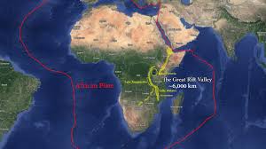
To understand the magnitude of this event, one must first grasp the sheer scale of the East African Rift Valley. This is not a minor geological fault line but a colossal fracture stretching approximately 3,500 kilometers. It carves a path through the continent, beginning at the strategic waters of the Red Sea in the north and extending all the way down to Mozambique in the south. The landscape of this region is defined by its dramatic topography, characterized by steep fault scarps, vast elongated depressions, and a topography that visually narrates the story of crustal extension.
Key Features and Distinct Branches
The rift is not a singular, uniform crack; rather, it is a complex system composed of two distinct branches that highlight the diverse nature of tectonic activity.
- The Eastern Rift (Gregory Rift):
Running through Ethiopia and Kenya, this branch is renowned for its fiery temperament. It hosts a high concentration of volcanic activity and is home to some of the continent's most iconic peaks, including Mount Kilimanjaro and Mount Kenya. Here, the crust is being pulled apart, allowing magma to rise close to the surface, fueling geothermal power stations that are vital to the region's economy.
- The Western Rift (Albertine Rift):
Traversing nations from Uganda to Malawi, this branch is less volcanic but seismically intense. It is marked by deep, water-filled gashes in the earth, creating some of the world's deepest and oldest lakes, such as Lake Tanganyika and Lake Malawi. These lakes are bordered by towering mountains like the Rwenzori range and are critical freshwater resources for millions of people.
Mechanism of Formation: The Engine Beneath
The splitting of a continent requires an incomprehensible amount of energy, and the source of this power lies deep beneath the Earth's crust. The primary driver of the East African Rift is believed to be a massive "superplume", a giant upwelling of hot rock rising from the deep mantle. This phenomenon, often referred to as the African Superplume, creates a thermal anomaly beneath East Africa, elevating heat flow and increasing buoyancy. As this superheated material rises, it pushes against the lithosphere (the rigid outer part of the earth), causing the land above to dome and uplift.
Structural Evolution and Horst-Graben Architecture
This uplift is the precursor to the rift. As the lithosphere is pushed upward, it stretches and thermally weakens. The process is akin to stretching a piece of toffee; as it pulls apart, it thins in the middle. In geological terms, this thinning allows for magmatism. Basaltic volcanism and fissure eruptions begin to occur, filling the widening valley floor with molten rock. The visual result of this process is known as "Horst and Graben" architecture. As the crust stretches, blocks of land detach and drop down between the faults, creating valleys known as grabens. The adjacent blocks that remain relatively high are known as horsts. This dropping and rising effect creates the classic trough-like structure of the Rift Valley.
The Afar Triple Junction: The Crucible of Creation
At the northernmost tip of this rift system lies one of the most geologically significant locations on the planet: the Afar Triple Junction. This area acts as the nexus point where three powerful rift systems converge : the Red Sea Rift, the Gulf of Aden Rift, and the East African Rift. It is a highly dynamic tectonic zone where the Earth's crust is being pulled in three different directions simultaneously.
Evidence from the Archives
The recent study highlighting the 1960s magnetic data focused heavily on this region. Magnetic surveys are crucial in geology because as new crust forms from cooling magma, magnetic minerals within the rock align with Earth's magnetic field. Since Earth's magnetic field reverses polarity every few hundred thousand years, these rocks create a "barcode" of magnetic stripes on the seafloor. The re-analysis of the 1960s data confirmed that these magnetic stripes—the hallmark of seafloor spreading—are present in the Afar depression. This confirms that the transition from "continental rifting" to "seafloor spreading" is already underway. The divergence between the Nubian and Somali plates is measurable here, estimated between 5 to 16 millimeters per year. While this may seem negligible on a human timescale, in geological terms, it is a sprint.
Ecological and Anthropological Significance
Beyond geology, the East African Rift is a cradle of life and evolution. The unique isolation provided by the rift lakes has led to an explosion of biodiversity found nowhere else on Earth.
- Evolutionary Radiations: Lake Tanganyika and Lake Malawi are famous for their Cichlid fish. Hundreds of species have evolved from a few common ancestors in a relatively short geological time, adapting to every niche in these deep, isolated rift lakes. This phenomenon is often cited by biologists as one of the best examples of vertebrate evolution in the world.
- The Cradle of Humanity: The Rift Valley is also inextricably linked to our own origins. The Afar region, specifically, is where the famous fossil "Lucy" (Australopithecus afarensis) was discovered. The geological uplifting and subsequent exposure of ancient sedimentary layers have made this region the world's premier hunting ground for hominid fossils, helping anthropologists piece together the story of human evolution.
Socio-Economic Impacts: Risks and Opportunities
While the geological timeline spans millions of years, the human impact of the East African Rift is immediate and tangible. The active fissuring and faulting present significant socio-economic challenges for the nations located along the rift.
Infrastructure Risks and Geothermal Potential
Infrastructure is at constant risk; roads, railways, and power lines built across fault zones face the threat of severance. For instance, the Standard Gauge Railway (SGR) in Kenya, a critical trade artery, traverses this volatile terrain, requiring constant engineering vigilance. We have witnessed instances where large cracks have suddenly appeared, dissecting farms and highways (such as the Mai Mahiu - Narok road in Kenya), disrupting transportation and threatening settlements. Conversely, the thinning crust offers a massive opportunity in the form of geothermal energy. Kenya has successfully harnessed this, with the Olkaria geothermal plants providing a significant portion of the nation's electricity. Ethiopia is following suit, tapping into the rift's heat to power its industrial ambitions.
Future Trade Routes and Geographic Reconfiguration
The most significant long-term consequence is the formation of a new ocean basin. Current geological models suggest that once the continental rupture is complete, the Somali plate will fully separate from the African mainland. Water from the Indian Ocean will flood the rift valley, turning the Horn of Africa into a massive island continent. For landlocked nations like Uganda, Rwanda, or Zambia, this eventual formation of a seaway could provide direct access to the ocean, fundamentally altering their trade dynamics and economic potential. While this is a distant future, it highlights how geological destiny is intertwined with economic fate.
Conclusion
The East African Rift Valley is more than just a tourist destination or a geographical curiosity; it is a testament to the restless nature of our planet. The confirmation provided by the recent analysis of archival magnetic data reinforces our understanding that Africa is gradually parting ways with itself. While the complete separation of the Somali and Nubian plates will take millions of years, the process is well underway, manifested daily through seismic tremors, volcanic activity, and the slow but steady widening of the earth. Understanding these processes is vital for disaster mitigation and resource management in the region. As we watch the birth of a new ocean unfold in slow motion, we are reminded that the map of the Earth is never finished; it is a work in progress, constantly being redrawn by the powerful forces beneath our feet.