The Siliguri Corridor: India’s Strategic Lifeline
The Siliguri Corridor: India’s Strategic Lifeline
The Siliguri Corridor, popularly referred to as the “Chicken Neck,” is one of India’s most strategically significant geographic stretches. This narrow land passage connects the Indian mainland to the Northeastern region, comprising the Seven Sister states along with Sikkim. Despite its slender width, generally estimated at just over twenty kilometres, this corridor is indispensable for civilian travel, trade, and national defence. It forms the only terrestrial link to a region that is culturally rich, resource diverse, and geopolitically sensitive. The continued functioning of this corridor ensures economic integration, administrative continuity, and the seamless movement of goods and security assets to a part of the country that would otherwise be isolated.
Geographic Setting and Strategic Landscape
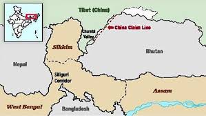
Positioned in northern West Bengal near the bustling city of Siliguri, the corridor occupies a uniquely delicate location. It is bordered by Nepal to the west, Bhutan to the north, Bangladesh to the south, and lies within proximity of China’s Tibet Autonomous Region. This rare convergence of international boundaries heightens the area’s vulnerability and elevates its strategic importance. All major transport arteries like national highways, railway lines, fibre networks, fuel pipelines, and military logistics corridors are compressed into this narrow tract, amplifying the consequences of disruption.
Beyond security considerations, the corridor is nestled among fertile plains and world-renowned tea estates, offering substantial economic value. It also acts as the primary access route to the Eastern Himalayas, enabling tourism flows to Sikkim, Darjeeling, and Bhutan. The surrounding ecological zones support biodiversity, cultural interactions, and livelihoods, making the corridor more than a strategic gap, it is a vital socio-economic connector for communities on both sides of its length.
Historical Evolution and Regional Relevance
The prominence of the Siliguri Corridor rose sharply after the 1947 Partition, when territorial boundaries separated India’s Northeast from the mainland except through this narrow land link. The creation of East Pakistan & later Bangladesh, further tightened the geographic passage. Following Bangladesh’s liberation in 1971, the corridor retained its relevance as the principal access route for administrative, commercial, and military purposes. Over subsequent decades, population growth, infrastructure expansion, and deeper integration of the Northeastern states increased the volume of movement through the corridor.
This strip of land gradually transformed into an artery supporting trade, defence deployment, and national consolidation. Highways now carry essential consumer goods, agricultural produce, petroleum supplies, and industrial commodities. Railways have strengthened cross-regional freight capacity. The region’s development ranging from hydropower to border trade centres, relies on the uninterrupted functioning of the corridor. Thus, safeguarding this narrow link is fundamental to maintaining territorial cohesion and facilitating the Northeast’s ongoing economic rise.
Geopolitical Risks and Security Complexities
The corridor’s limited width and adjacency to multiple international boundaries expose it to significant strategic risks. China’s expanded military capabilities in the Chumbi Valley, positioned between Sikkim and Bhutan, heighten India’s concerns about potential attempts to threaten or pressure the corridor. Events such as the Doklam standoff in 2017 demonstrated how tensions in adjoining high-altitude areas could have direct implications for the corridor’s security.
Additionally, geopolitical developments involving Bangladesh and Myanmar, both countries where China has been increasing diplomatic and infrastructural influence are watched closely by Indian strategic planners. The possibility of Chinese-aided surveillance infrastructure or air mobility capabilities near the corridor generates apprehension regarding future coercive scenarios. Beyond military challenges, the corridor is exposed to natural hazards including intense monsoonal flooding, river overflow, and landslides that can temporarily sever land routes. These environmental risks highlight the importance of resilient and diversified connectivity.
Defence Preparedness and Infrastructure Reinforcement
India has undertaken sustained measures to secure and strengthen the area surrounding the corridor. New military garrisons have been developed in Dhubri, Kishanganj, and Chopra, enabling faster mobilisation and coordinated operations. These facilities complement the forward presence of the Indian Army’s Trishakti Corps, responsible for defence across the region. Air power adds another layer of security through assets such as Rafale fighter aircraft stationed at Hasimara Air Force Station and integrated missile systems positioned across the eastern theatre.
These deployments create a multi-tiered security shield designed to deter any adversarial manoeuvre, ensure rapid response capacity, and maintain operational superiority. Alongside military installations, logistics upgrades, including improved road surfaces, widened transport routes, and enhanced supply depots, help guarantee uninterrupted support to forces stationed throughout the Northeast. The net outcome is a strengthened defensive posture positioned to safeguard the corridor under both conventional and hybrid threat scenarios.
Demographic Pressures and Social Security Dynamics
A further dimension influencing the corridor’s stability stems from demographic shifts linked to migration from across the Bangladesh border. Irregular movement of people into neighbouring districts has introduced challenges related to identity documentation, land pressure, cultural integration, and political sensitivity. These evolving demographic patterns have implications for administrative planning and local stability.
To address these concerns, the government has expanded border fencing programmes, implemented biometric monitoring systems, and increased the presence of security forces. Community awareness initiatives and coordination with local administrations aim to balance humanitarian considerations with national security. The ethnic diversity of the region, representing multiple linguistic and cultural groups, requires governance approaches that maintain social harmony while mitigating vulnerabilities.
Surveillance Networks and Multi-Agency Coordination
The security architecture protecting the Siliguri Corridor relies on integrated cooperation between the Indian Army, the Border Security Force, intelligence agencies, and state authorities. Advanced monitoring tools such as unmanned aerial vehicles, satellite imagery, electronic sensors, and upgraded communication grids enhance border observation and rapid alert mechanisms. These technologies support efforts to prevent smuggling, illegal crossings, and infiltration attempts.
Joint operations and information-sharing protocols ensure that response mechanisms remain unified and efficient. Crisis simulations, patrol synchronisation, and coordinated planning build preparedness against a range of contingencies, from border incidents to infrastructure disruption. This fusion of civil-military cooperation strengthens the corridor’s resilience and demonstrates the importance of institutional coherence in safeguarding strategic zones.
Connectivity Alternatives and Strategic Diversification
Recognising the risks inherent in relying on a single passage, India has pursued alternative connectivity pathways to complement the Siliguri Corridor. Diplomatic engagement with Bangladesh has opened avenues for transit routes such as the proposed Hili–Mahendraganj passage, which could ease transport burden and increase redundancy. Infrastructure projects including elevated highways, bypass routes, and rail upgrades help mitigate congestion and reduce vulnerability.
The Kaladan Multi-Modal Transit Transport Project, linking Kolkata to Mizoram through Myanmar, represents another long-term initiative aimed at expanding regional access. These projects align with India’s Act East policy, deepen economic cooperation, and provide additional channels for troop and supply movement in crisis conditions. In parallel, recent military drills and air power demonstrations in the eastern sector signal India’s readiness to defend the region while reinforcing diplomatic deterrence.
Conclusion
The Siliguri Corridor remains one of India’s most crucial geographic connectors and a focal point of strategic planning. Its narrow structure, complex border surroundings, and geopolitical sensitivity make it both vital and vulnerable. Ensuring its protection requires a blend of military preparedness, infrastructure reinforcement, regional diplomacy, technological surveillance, and diversified connectivity planning. As India continues to strengthen its Northeastern integration and enhance national security resilience, the Siliguri Corridor stands as a defining example of how geography shapes strategy, stability, and national cohesion.