The Rising Wall of Dust: Aravalli Degradation and the Expanding Footprint of India’s Pre-Monsoon Storms
The Rising Wall of Dust: Aravalli Degradation and the Expanding Footprint of India’s Pre-Monsoon Storms
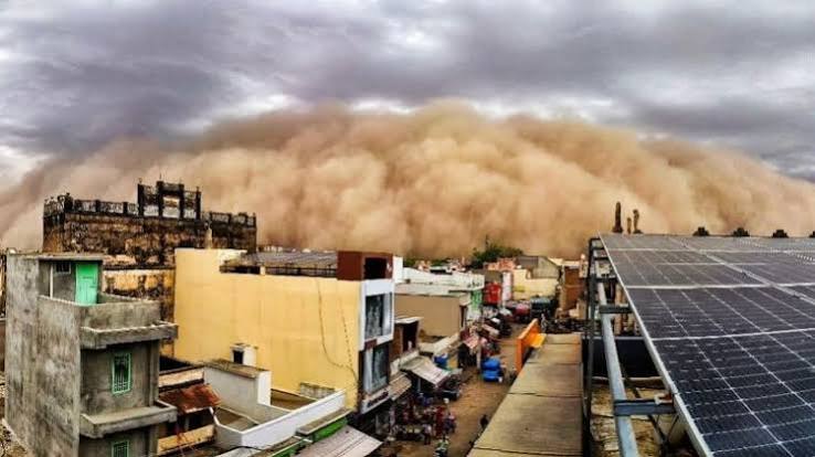
On May 30, 2026, a massive dust storm swept across Churu and several neighboring districts of Rajasthan, turning the afternoon sky into an ominous blanket of amber and grey. While localized dust storms, colloquially known as Andhi are familiar occurrences in the arid landscapes of Northwest India, the sheer intensity and expansive reach of this particular event signaled a deeper ecological crisis. Historically, the semi-arid plains of India have relied on a natural geographic buffer to contain the harsh climate of the Thar Desert. However, this recent meteorological surge has highlighted a critical and dangerous vulnerability: the severe structural and ecological degradation of the ancient Aravalli mountain range. No longer acting as an impenetrable shield, the crumbling mountain belt is allowing desert conditions to creep deeper into the country's fertile heartland.
For generations, the Aravallis functioned as India’s primary ecological defense system against desertification, checking the eastward march of the desert and scrubbing the air clean. As human activities dismantle this ancient geological barrier, the environmental equilibrium of Northern India is shifting. The dust storms originating in the desert fringes are no longer confined to their historical boundaries; instead, they are carving out a broader, more destructive trajectory. To understand the gravity of this transition, it is necessary to examine the foundational physics of these storms, the human-induced gaps facilitating their free passage, and the long-term regional consequences that threaten public health, agriculture, and urban stability across the Indo-Gangetic plains.
The Dynamics of Atmospheric Lifting and Desert Convection
A dust storm is fundamentally a high-energy meteorological phenomenon born from intense thermal instability. During the scorching pre-monsoon months of April, May, and June, the Thar Desert becomes a focal point for extreme solar radiation. As the bare earth absorbs heat, the air directly above it warms rapidly, expands, and ascends violently into the atmosphere, creating localized pockets of severe convective instability. This rapid upward movement of superheated air generates a powerful surface low-pressure system, a thermal void that acts as an atmospheric vacuum.
To fill this vacuum, strong, turbulent south-westerly and westerly winds rush across the arid terrains of the Middle East and the Thar Desert, gathering momentum as they travel. When these winds breach a critical mechanical velocity threshold—typically between 35 and 40 kilometers per hour—they exert enough shear stress on the ground to lift loose, un-vegetated surface soil particles into the air. Through a process known as saltation, bouncing sand grains strike smaller dust particles, launching them high into the upper atmosphere. Without a continuous, densely forested mountain range to intercept these high-velocity winds and disrupt their airflow, millions of tons of airborne sediment are carried thousands of kilometers eastward, coalescing into a sweeping wall of dust that completely blankets the region.
The Geography of Vulnerability Across Northern India
The primary impact zone of these intensifying pre-monsoon storms is concentrated in Northwest India, but its outer boundaries are expanding rapidly. The immediate theater of impact remains the hyper-arid and semi-arid districts of western and northern Rajasthan, including Bikaner, Hanumangarh, Jodhpur, and Churu. In these zones, the immediate consequences are felt in the form of sudden, near-zero visibility, halted transportation networks, and severe structural damage caused by high-velocity winds.
However, the trajectory of these storms does not stop at the desert margins. Sweeping past the historical barrier of the Aravallis, the sediment-laden winds advance directly into the National Capital Region (NCR), making Delhi-NCR a major urban victim of these events. Climatological data compiled by the India Meteorological Department (IMD) reveals that Delhi experiences an average of 2.5 dust-storm days in June alone, marking the highest frequency of such urban atmospheric disruptions anywhere in India. From the capital, the dust plumes fan out across the adjoining fertile plains of Punjab, Haryana, and western Uttar Pradesh. As the geographical barrier fails, the dust trajectory extends deeper into the densely populated Indo-Gangetic basin, transforming a localized desert phenomenon into a sweeping regional crisis.
The Loss of the Aravalli Scrubbing Mechanism
To appreciate why modern dust storms travel with such unprecedented ease, one must understand the historical blueprint of the region's ecology. For millennia, the western slopes of the Aravalli range operated as highly efficient, natural physical interceptors. When sediment-heavy desert winds collided with the elevated topography of the mountains, they were forced to lose velocity. As the wind slowed, it dropped its heavy payload of sand and coarse silt along the western slopes, leading to the formation of unique geographical features known as obstacle sand dunes.
These obstacle dunes were not merely passive piles of sand; they were anchored and stabilized by specialized, deep-rooted native desert vegetation. This natural arrangement performed an invaluable "air scrubbing" service for the Indian subcontinent. The physical mass of the mountains blocked the lower, sediment-dense layers of the wind, while the dense forest canopy absorbed fine particulate matter, effectively purifying the air mass before it could spill over into the northern plains. Today, the systematic denudation of these slopes has stripped the mountains of their scrubby forest cover, neutralizing this ancient filtration process and leaving the regions downwind entirely exposed.
Anthropogenic Fractures and the Vanishing Topography
The modern amplification of dust storms is directly linked to human activities that have structurally fractured the Aravalli range. A landmark spatial study conducted by the Wildlife Institute of India (WII) confirmed the existence of 12 distinct, widening operational gaps across the mountain range. These gaps are not natural geographic passes; rather, they are structural voids created by severe forest fragmentation, unchecked livestock overgrazing, and rapid urban encroachment. These 12 corridors now act as atmospheric funnels, allowing high-velocity desert winds to pass through the mountain line completely unimpeded.
Worse still is the literal erasure of the region's topography. Assessments by the Forest Survey of India (FSI) have documented that at least 31 entire hillocks within the Aravalli system have completely disappeared from the map. Driven by a booming demand for construction materials in surrounding urban centers, rampant illegal mining has systematically ground down these ancient hills for red silica, granite, and building aggregates. By leveling these physical massifs, human enterprise has stripped away the aerodynamic friction that once disrupted storm systems, transforming a complex, protective mountain system into a flattened, open highway for desert weather.
Public Health Consequences and the Particulate Surge
The environmental degradation of the Aravallis has direct, measurable consequences for human health. When a dust storm moves through a region without passing through an ecological filter, it causes an immediate and extreme surge in airborne particulate matter concentrations, particularly coarse particles less than 10 micrometers in diameter (PM10). During severe pre-monsoon events, PM10 levels in cities like Delhi and Jaipur regularly spike to many times the safe thresholds prescribed by the World Health Organization, plunging urban and rural populations into hazardous breathing environments.
This persistent exposure to high-density crustal dust triggers a cascade of chronic and acute health crises. Local populations face skyrocketing rates of respiratory ailments, including acute asthma exacerbations, chronic bronchitis, and severe cardiovascular strain. In rural areas directly adjacent to mining sites and storm pathways, the inhalation of fine crystalline silica dust leads to high rates of silicosis, an irreversible, debilitating lung disease. The lack of an environmental buffer has effectively converted seasonal weather events into recurring, regional public health emergencies.
The Silent Threat of Agricultural Desertification
Beyond the immediate health risks and visibility hazards lies a quiet, long-term threat to India’s food security: the acceleration of agricultural desertification. The widening structural gaps in the Aravallis allow arid, nutrient-poor desert sands to spill directly onto the fertile agricultural croplands of Haryana, Punjab, and Western Uttar Pradesh—a region often referred to as the breadbasket of India.
As these intense winds deposit coarse, infertile desert sand over highly productive alluvial soils, they alter the soil composition, diluting vital organic matter and reducing water-retention capacity. Over time, this wind-driven sand encroachment degrades highly productive fields into semi-arid rangelands, driving down crop yields and depleting precious groundwater reserves as farmers try to irrigate their degrading lands. The erosion of this mountain barrier is slowly compromising the underlying ecological stability required to sustain regional agriculture.
Strategic Eco-Restoration and Environmental Preservation
Reversing this trajectory requires a shift from passive monitoring to aggressive, landscape-scale ecological restoration. The most critical step forward is the swift, well-funded implementation of the Aravalli Green Wall Project. This ambitious initiative aims to establish a continuous, 1,400-kilometer-long and 5-kilometer-wide ecological buffer zone of native, drought-resistant trees stretching across Gujarat, Rajasthan, Haryana, and Delhi. Replanting native species like Acacia tortilis, Khejri, and various indigenous shrubs will rebuild the lost canopy cover, bind the loose topsoil, and restore the physical friction needed to disrupt incoming dust storms.
Simultaneously, state governments must enforce strict, uncompromising judicial limits on active mining leases and halt all illegal quarrying. Vulnerable, heavily exploited mining corridors like Sariska, Kotputli, and parts of Haryana must be declared strict ecological preservation zones. To ensure compliance, authorities should deploy drone-based surveillance networks and real-time satellite imaging to track land-use changes, monitor slope stability, and instantly detect illegal mining operations. Protecting Northern India's environment requires treating the Aravallis not as a source of cheap building aggregates, but as an irreplaceable infrastructure asset for climate defense.
Conclusion
The escalating intensity of pre-monsoon dust storms across Northwest India is a clear indicator of regional ecosystem collapse. The Aravalli range has never been a static row of rocks; it is a living, functional climate regulator that maintains the delicate environmental balance of Northern India. The structural fractures in this ancient mountain chain have turned a local desert phenomenon into a regional threat that compromises public health, food production, and economic stability across the Indo-Gangetic plains. Restoring and protecting this geographic shield is no longer just an environmental ideal, it is a strategic necessity to ensure the long-term climate resilience of the region.