The Geopolitics of Katchatheevu Island: Maritime Boundaries and Bilateral Diplomacy
The Geopolitics of Katchatheevu Island: Maritime Boundaries and Bilateral Diplomacy
The tiny, uninhabited island of Katchatheevu, nestled in the narrow corridor separating India and Sri Lanka, remains one of South Asia’s most legally complex and politically sensitive maritime subjects. Spanning just 285 acres, this rocky islet in the Palk Strait punches far above its geographical weight in regional diplomacy. While the island does not support permanent human habitation due to a lack of fresh water, its surrounding waters hold immense economic value for traditional fishing communities. Decades after formal treaties appeared to settle its administrative status, Katchatheevu frequently re-emerges in public discourse, serving as a touchstone for discussions on state sovereignty, historical fishing rights, and international law.
Context and Current Diplomatic Standpoint
The status of the island gained renewed traction during a high-profile goodwill visit to Chennai by Sri Lankan Member of Parliament Rauff Hakeem. Addressing questions on the persistent friction surrounding the territory, Hakeem asserted that the sovereignty of Katchatheevu is an entirely settled matter under international law and existing bilateral covenants. This perspective reflects the official stance of Colombo, which views the island as an integral part of its Northern Province territory. The statement underscores a broader diplomatic consensus within Sri Lanka that the maritime boundaries established in the mid-1970s are definitive and non-negotiable. From a legal standpoint, any modern attempt to alter or re-examine the administrative control of the island cannot be executed unilaterally by either country. Instead, such modifications would require mutual bilateral renegotiation or a formal appeal through the United Nations framework, a path that neither nation has formally pursued.
Geographical and Ecological Profile of the Islet
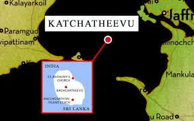
Geographically, Katchatheevu is situated within the Palk Strait, a shallow body of water that divides the southern coast of Tamil Nadu in India from the Jaffna peninsula of Sri Lanka. The island lies approximately 14 nautical miles from Rameswaram on the Indian mainland and roughly 9 nautical miles southwest of Delft Island in Sri Lanka. It sits precisely on the Sri Lankan side of the established International Maritime Boundary Line. Because it is devoid of natural drinking water sources, the island has never sustained a permanent civilian population.
Despite its barren terrestrial landscape, the marine environment surrounding Katchatheevu is incredibly rich and biologically diverse. The shallow Palk Bay waters act as a fertile breeding ground for numerous high-value marine species, particularly prawns, chank, and various commercial fish. However, this rich ecosystem is under severe environmental stress. In recent years, the intensive use of heavy mechanized bottom trawlers, banned fishing gear, and destructive commercial harvesting practices has led to significant habitat degradation, threatening the long-term sustainability of the local marine ecology.
Historical Claims and the Zamindari Era
Before becoming a flashpoint between independent nation-states, Katchatheevu was governed through complex pre-colonial and colonial administrative frameworks. Historically, the island fell under the jurisdiction of the Ramnad Kingdom, a princely estate located in modern-day Tamil Nadu. During the British colonial era, this territory was formalized as the Ramnad Zamindari, and the local rulers routinely exercised administrative and economic control over the island. They collected revenue, leased out fishing rights, and managed the gathering of various marine resources around the islet. Indian fishing communities from the Coromandel Coast utilized the island for centuries as a vital transit point, using its shores to anchor their wooden boats, dry their catch, and repair their handmade cotton fishing nets. These deep-rooted historical practices formed the bedrock of India's traditional claims to the territory, creating an enduring socio-cultural connection between the fishermen of Tamil Nadu and the distant island.
The Maritime Boundary Agreements of 1974 and 1976
The legal status of Katchatheevu underwent a fundamental transformation during the mid-1970s through a series of bilateral agreements aimed at resolving maritime ambiguities between India and Sri Lanka. Under the leadership of Prime Minister Indira Gandhi and Sri Lankan Prime Minister Sirimavo Bandaranaike, the two nations sought to establish a clear International Maritime Boundary Line.
- The 1974 Agreement: India formally recognized Sri Lanka’s sovereignty over Katchatheevu. The treaty was signed to foster strong neighborhood relations and replace historical ambiguities with a clear boundary framework based on international legal concepts. However, this agreement remains constitutionally contested within India. Critics and legal experts often cite the landmark Berubari Union case (1960), arguing that any cessation of territory to a foreign power requires a formal Constitutional Amendment passed by Parliament, which the 1974 executive pact bypassed.
- The 1976 Agreement: A subsequent pact further clarified the maritime boundaries in the Gulf of Mannar and the Bay of Bengal, strictly demarcating the Exclusive Economic Zones (EEZs) of both countries.
Crucially, a significant legal contradiction exists between the two texts. While Article 5 of the 1974 agreement protected the traditional rights of Indian fishermen to access the island's waters without documents, an exchange of letters during the 1976 treaty effectively stripped away these commercial permissions. This subsequent framework strictly restricted fishermen from both nations from fishing in each other’s sovereign waters without prior state permission, effectively ending regular, unrestricted Indian commercial fishing operations on the Sri Lankan side of the boundary line.
Cultural Synergy and St. Antony’s Church
Despite the rigid geopolitical boundaries drawn by the treaties, Katchatheevu continues to serve as a unique space for cross-border cultural and spiritual convergence. The island houses the historic St. Antony’s Church, a shrine dedicated to the patron saint of seafarers. Every year, the chapel hosts a celebrated two-day religious festival that draws thousands of Christian pilgrims from both India and Sri Lanka. This annual pilgrimage functions under a special arrangement that temporarily bypasses rigid international travel protocols.
Indian citizens traveling to the festival are granted unrestricted access to the island, meaning they do not require formal passports or visas to attend the ceremonies. The Sri Lankan Navy, in coordination with local administrative bodies, manages the logistical infrastructure for the event, ensuring safe passage, temporary shelter, and assistance for the visiting Indian devotees. This annual event acts as a vital cultural bridge, allowing traditional fishing communities from both sides of the strait to share a common space, reinforce ancestral ties, and express a shared maritime heritage that predates modern political borders.
The Fishing Rights Conflict and Livelihood Challenges
The divergence between historic traditional practices and modern legal boundaries has given rise to an ongoing, volatile conflict regarding fishing access in the Palk Strait. This clash is deeply rooted in an economic asymmetry: while northern Sri Lankan Tamil fishermen rely on modest, traditional artisan fishing methods after losing their livelihoods during decades of civil war, Indian fleets often employ large-scale, mechanized bottom trawlers. As fish stocks on the Indian side of the maritime border depleted due to overfishing, Tamil Nadu fishermen increasingly crossed the International Maritime Boundary Line into the well-preserved waters around Katchatheevu.
This regular crossing has led to frequent security confrontations. The Sri Lankan Navy routinely patrols the zone to protect its domestic northern fishermen. These enforcement operations frequently result in the arrest of Indian fishermen, the confiscation of expensive mechanized boats, and occasional tragic fatalities at sea. The issue is deeply tied to the local economy of coastal Tamil Nadu, creating significant domestic political pressure on the Indian central government to secure the release of detained citizens and find a permanent diplomatic remedy to safeguard their livelihoods.
Conclusion
Katchatheevu Island stands as a classic case study in how historical inheritance, domestic livelihood concerns, and international treaties intersect in modern geopolitics. While the legal treaties of 1974 and 1976 established a clear administrative reality under international law, the lived realities of traditional fishing communities continue to push against these official boundaries. Balancing the sovereign rights of Sri Lanka with the humanitarian and economic needs of Indian fishermen remains a delicate diplomatic tightrope. Ultimately, resolving the lingering friction around Katchatheevu requires sustained, cooperative bilateral dialogue, joint environmental management of the Palk Strait, and a shared commitment to keeping the spirit of peaceful co-existence alive.